BUY
online
, several scenic hiking trails branch out into the Tatra Mo...&p[url]=https://www.pkl.pl/post/kasprowy-wierch/key-attractions/kasprowy-wierch-hiking-map.html&p[images][0]=https://www.pkl.pl/data/posts/2419/foto-www.jpg)


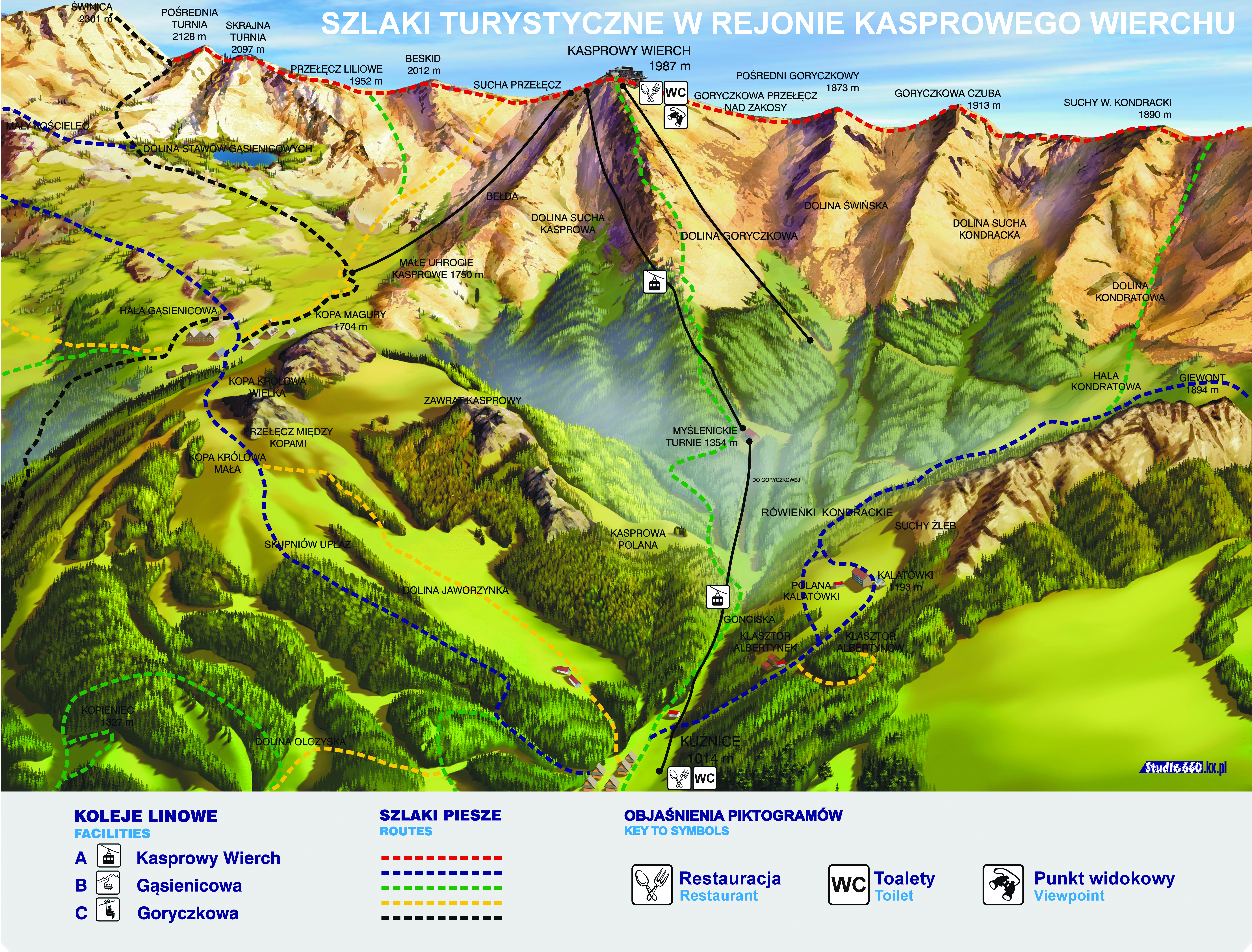
Kasprowy Wierch Hiking Map
Starting from the top station of the cable car (1,987 m a.s.l.), several scenic hiking trails branch out into the Tatra Mountains. Each route offers different levels of difficulty and duration, perfect for both casual walkers and seasoned hikers.
Main Routes:
Kasprowy Wierch → Świnica (via Liliowe Pass)
Difficulty: High | Time: approx. 2.5–3 h one way
A challenging trail with panoramic ridge views, suitable for experienced hikers.
Kasprowy Wierch → Kopa Kondracka
Difficulty: Moderate | Time: approx. 2 h
A part of the main Tatra ridge trail (Red Trail), leading westward. Stunning views over the Western Tatras.
Kasprowy Wierch → Myślenickie Turnie → Kuźnice
Difficulty: Medium | Time: approx. 2–2.5 h descent
Follows the cable car’s route downhill, offering beautiful views and a quieter descent through alpine vegetation.
Kasprowy Wierch → Gąsienicowa Valley → Hala Gąsienicowa → Kuźnice
Difficulty: Moderate | Time: approx. 3–3.5 h descent
A scenic descent through a picturesque valley, with a stop at the Murowaniec mountain shelter.
Kasprowy Wierch → Brzeziny (via Gąsienicowa Valley)
Difficulty: Moderate | Time: approx. 3.5–4 h
A longer route ending near Zakopane, ideal for those heading back without using the cable car.
Tips for Hikers:
Always check the weather before heading out — conditions in the Tatras change rapidly.
Bring appropriate footwear, clothing, and water.
Mobile coverage may be limited in some areas.
The “Kasprowy Wierch” mobile app offers offline maps, trail descriptions, and audio guides.